
Ground Truth — The Map That Became the World
An AI-built world where a one-to-one cartographic Overlay renders every place as the version the world remembers — 27 atoms, five hard rules about maps, and four published key visuals from a GPT Image 2 vs Krea 2 comparison. Out past the shipping lanes, a white hole is growing where a town used to be.
Worldview
In 2005 the Meridian Survey switched on the Overlay, a cartographic layer wrapped around the whole planet at one-to-one scale. It does not photograph the Earth. It renders each place as the version of itself that the world collectively remembers: the street everyone agrees is there, the shoreline from the postcard, the rooftops from the year the town was proudest. Roads, borders and buildings answer to that rendering. Redraw a street and the asphalt follows within a season. Blank a tile and the place still exists, but no road will take you there and no map will admit you arrived.
Twenty-one years later the Survey is losing tiles by the thousand. A movement called the Blank is erasing places on purpose, one road at a time, so that a town can be lived in rather than found. The only people who still know what the ground actually looks like are the ones who never trusted the map: paper cartographers under Lisbon, a seam-walker who steps between panoramas, a pilot flying the last unautomated verification route over the ice.
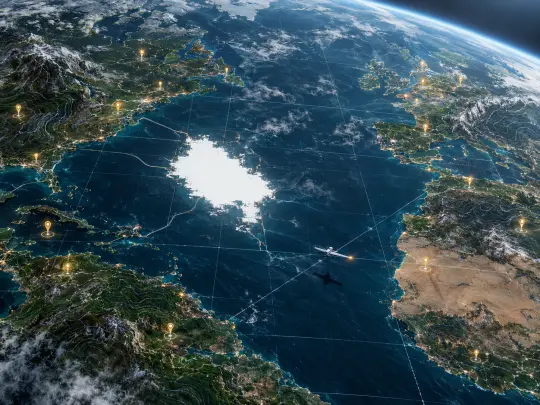
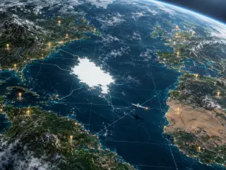
Visual style: photoreal orbital and aerial imagery fused with precise cartographic linework — a faint geometric tile grid, hairline survey seams, contour lines, suspended placemark pins, and one region of pure unrendered white. Deep ocean blue, ash grey, map-cream and a single brass pin light. Rendered with GPT Image 2 and Krea 2 from the same two prompts.
Characters (7)
Locations (6)
Events (5)
Factions (4)
The Five Rules of the Overlay
The rules are the reason this setting can hold a story. Each one is a hard constraint that produces a different kind of scene, and each one can be broken exactly once before the world notices.
The Overlay: A Second Skin at One-to-One
Most map stories are about a place that is hidden. Ground Truth is about a place that is over-documented. The Overlay does not cover the Earth like a screen; it is registered to it, tile by tile, so that the rendered version and the physical version have to agree at the edges. That single design decision generates everything else: politics, because consensus becomes infrastructure; crime, because pins are property; grief, because a blanked town is not destroyed but unreachable; and horror, because a white hole in the Atlantic is not a hole in the map. It is a hole in the world’s agreement about what is there.
Point Nemo: The Largest Blank on Earth
The oceanic pole of inaccessibility is the farthest point from any land, which makes it the one place the Overlay has never bothered to render in detail. The Blank did not create the blank at Point Nemo. They recognized it. In the world’s art it is a cathedral without a roof: open water, a survey buoy, a ring of undisturbed white where the tile budget ran out, and a horizon that does not resolve. When a scene needs to feel like the end of a jurisdiction, it happens here.
Vatnajökull: Twenty Years Stacked in Ice
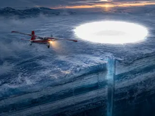
The Time Slider is the most physical rule in the world, and Vatnajökull is where it becomes visible. Historical imagery froze into the ice cap as real strata: one blue-white band per year of coverage, compressed and readable, with survey stakes driven through them. The White Flight cut a vertical shaft through the strata where a year had been removed — a missing band you can stand inside. It is the only place in the setting where you can point at a date and fall through it.
Meridian House: The Globe in the Lobby
The Survey’s headquarters sits on the zero meridian with a forty-metre globe in the lobby, lit from above so that it is always late afternoon somewhere. Every tile on Earth is represented on that globe, including the ones that are failing. Visitors are told the globe is an index. Staff call it the ledger. In practice it is the closest thing the world has to a parliament: whatever the globe shows at 04:00 is what the roads will do by noon.
The Blank: Erasure as Infrastructure
The Blank is not a cult and not a terror group, which is what makes it usable in a story. It is a maintenance philosophy with a road crew. Its argument is simple: a place that is findable is a place that can be optimized, priced, routed through and emptied of anyone who cannot afford the route. Erasing a tile does not kill the town. It removes the road, the listing, the delivery radius and the pin — and leaves the people who stayed with a place that is finally only theirs. The horror is that the argument works.
Works from This World
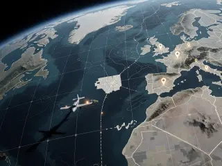
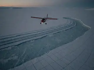
Four key visuals were generated from this world and published as shareable works: two briefs, two models, one prompt each. The first pair renders the Overlay as a world — the planet-scale view with its grid, pins and white absence. The second pair renders the White Flight as an event — a survey plane, a glacier cut open by year, and a hole where a town used to be. Every image on this page is one of those four works, published from this world and remixable.
Model Comparison: GPT Image 2 vs Krea 2
The same prompt, two very different documents. GPT Image 2 leans detail-first: it builds an actual planet with cloud decks, coastal shelves and city lights, registers the grid to the curvature of the Earth, gives each pin its own small shadow, and makes the white absence look like a hole burned through a photograph. Krea 2 leans atmosphere-first: it flattens the same brief into a colder, greyer cartographic diagram, keeps the graticule perfectly square, and turns the erased town into an unrendered white grid that reads instantly at thumbnail size. Neither is the correct answer. GPT Image 2 sells a place you could fall into; Krea 2 sells a document you could file.
The White Flight, Examined
The event pair is the harder brief, because it has to hold a machine, a landscape and a human absence in one frame. GPT Image 2 solves it with weight and light: the glacier’s strata are legible as years, the shaft is cut with real depth, the white hole has a rim and a faint town inside it, and the plane’s landing light is the only warm pixel in the frame. Krea 2 solves it with staging and restraint: the same plane at the same dusk, the strata reduced to stepped shelves, and the erasure rendered not as a glowing hole but as a survey grid that stops being ice. One is a still from a film about losing a place. The other is the last photograph taken before the loss.
Why a Map Is a Better Setting Than a Place
A map is a promise that everything on it can be reached. Break that promise in a controlled way and you get a setting with built-in stakes, built-in politics and a visual language the audience already reads without being taught. That is the whole design of Ground Truth: the map is not a prop, it is the antagonist, the infrastructure and the crime scene.
- Every location is a decision. A place exists on the page because someone pinned it, funded it and verified it. That makes geography political without a single speech.
- Distance is legible. Readers already know what a coastline, a seam and a tile grid mean, so the art can spend its detail on the anomaly instead of the explanation.
- Erasure is visual. White space reads as absence at any size, in any language, on any screen — which makes it the cheapest and most reliable horror in the setting.
- Scale is free. The same world supports an orbital key visual, a street-level scene and a one-page document, because the map already contains all three zoom levels.
From Seed to Key Visual
Choose the seed
Fork Ground Truth, or write a one-sentence brief about a map that renders places as they are remembered rather than as they are.
Pick the scale
Orbit for the world key visual, low aerial for an event, street level for a character cover. The same atoms hold at all three.
Name the anomaly
One white absence, one missing year, one pin that should not be there. A map image needs exactly one thing that does not belong.
Render both models
Run the identical prompt through GPT Image 2 and Krea 2. Both results publish as works of the world, so the comparison costs one extra render.
Publish and fork
Publish the pair, compare them at full size and at thumbnail size, then change one variable — never the scale, the anomaly and the light at once.
Fork world → Edit atom cards → Generate key visuals, maps and scenes → Publish as works → Others fork your version
A World Page, Not a Work Page
In Neta Studio a world is the beginning of everything. A world holds the characters, locations, events, factions and rules; a work is one frame pulled out of it. This page is a world page, which means the four images below are not the product — they are evidence that the setting holds up when you point a camera at it. The same coastline can become a 2005 launch poster, a 2026 survey briefing, a game level, a five-second loop of a tile going white, or a character cover for Iris Vale. Because the atoms are fixed, all of those stay recognisably the same planet.
World → Key Visual
One prompt per scale: orbital, aerial, street. The world supplies the grid, the palette and the anomaly; the model supplies the light.
World → Playable Scene
Pick a location and a rule. Point Nemo plus The Blank is a survival scenario. Meridian House plus Placemarks is a heist.
World → Asset Library
Every character generates a cover, every location a background, every rule a diagram. The world itself is the asset pack.
Who This World Is For
Readers of cartographic science fiction who want the map to be the villain rather than the backdrop. Game masters who need a modern setting with a clean visual grammar and no dragons. Concept artists who want to work in orbital imagery and survey linework without building a whole planet from scratch. Writers who like rules more than twists. And anyone who has ever zoomed into a satellite view of their own street and felt, for a second, that the version on the screen was the one that counted.
Frequently Asked Questions
- Is this Google Earth? No. Ground Truth is an original AI-built world inspired by satellite-map interfaces and the way people read them. It is not affiliated with, endorsed by, or connected to Google or Google Earth.
- What can I do with it? Fork it, edit its 27 atoms, generate new key visuals, build a playable scenario, or use it as the setting for a table. Every work published from it is remixable.
- Which models made the art? GPT Image 2 and Krea 2, from the same two prompts, published as four works of this world.
- Do I need to know the setting? No. The rules carry it: the map renders memory, a pin fixes a version, seams are doors, erasure spreads along roads, and the time slider costs you one object.
- Why is there so much white? Because erasure is the world’s central image. A blank tile is not empty space — it is a place that still exists and can no longer be reached.
Start Creating
Create from Ground Truth
Fork the world, inherit its 27 atoms and four published key visuals, then decide which version of the planet your story is allowed to remember.