
Google Earth-Inspired Worlds — Build a Living Map Setting with AI
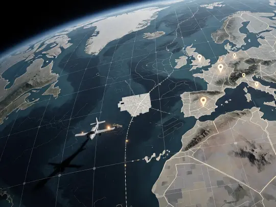
A use-case guide to building Google Earth-inspired AI worlds: map-first world design, the Ground Truth example, model comparison and a repeatable prompt workflow.
Build a world the map can lose
From a satellite interface to a living map that renders places as they are remembered — a tile grid, a placemark pin, a survey seam, and one white hole where a town used to be.
What Is a Google Earth-Inspired World?
A Google Earth-inspired world is a fictional setting built on the grammar of satellite maps: a globe you can spin, a tile grid you can zoom into, pins that mark what matters, seams where two photographs meet, and a time slider that lets you fall backwards into an older version of a place. The interface is familiar enough that an audience needs no tutorial, which frees the story to spend its attention on what is wrong with the map. In practice that means one deliberate contradiction: a place that is over-documented, a tile that has stopped rendering, a pin that fixes a town to a version of itself nobody voted for.
This page uses a real Neta Studio world as the worked example. Ground Truth is set in 2026, twenty-one years after the Meridian Survey switched on the Overlay — a cartographic layer wrapped around the whole planet at one-to-one scale that renders every place as the version of itself the world collectively remembers. Roads follow the rendering, pins fix versions, seams are doors, and a movement called the Blank is erasing places on purpose, one road at a time.
Why Map Interfaces Make Strong Fictional Settings
- The audience already reads it. Coastlines, grids, pins, zoom levels and loading tiles need no explanation, so every visual anomaly lands immediately.
- Geography becomes politics. If a place exists because it was pinned, funded and verified, then the map is a budget and the budget is a government.
- Scale is built in. The same world supports an orbital poster, a street-level scene and a one-page briefing without changing its visual language.
- Erasure is legible. White space reads as absence in any language, at any size, on any screen — the cheapest and most reliable image of loss available.
- It is contemporary. No dragons, no post-apocalypse, no spaceship. A satellite map is the most familiar piece of science fiction the present already owns.
The World Behind This Page: Ground Truth
Ground Truth holds 27 atoms: seven characters, six locations, five events, four factions and five rules. The cast is built around the seam between the map and the ground — a tile chief who founded the Blank, a surveyor trying to re-find her erased hometown, a paper cartographer who believes only ink can be wrong honestly, a seam-walker who steps between panoramas, a tile engineer who designs blanks that spread along roads, and a pilot who vanished over Vatnajökull after radioing a coordinate that exists on no layer. The locations are the places where the map is thinner than the ground: Meridian House, Point Nemo, the Atacama Node, the Paper Vault, the Serengeti Seam and the Vatnajökull Strata.
The Six Places Worth Rendering First
Casting the Map: Seven People Who Read the Overlay
A Timeline That Changes the Map
Four Powers, One Layer
The Rules That Make It a Story
The Key Visual Pair: Same Brief, Two Models
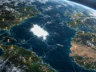
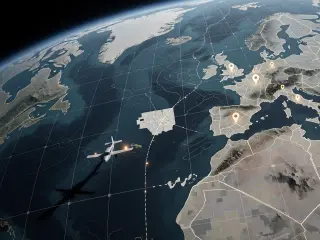
The world’s first two works render the Overlay at planet scale: a photoreal Earth seen from high orbit with the survey grid registered to its curvature, placemark pins suspended over coastal cities, contour lines pressed into the ranges, and a town-sized white absence in the Atlantic with a survey plane crossing its edge. The prompt was identical for both models. Only the renderer changed.
How GPT Image 2 and Krea 2 Split the Job
GPT Image 2 is the detail-first option, and for an orbital shot that matters more than usual: it builds cloud decks, coastal shelves, city lights and a grid that follows the planet instead of sitting flat on top of it. The white absence looks burned through a photograph rather than drawn onto a diagram, and each pin carries its own small shadow. Krea 2 is the atmosphere-first option: it flattens the same brief into a colder, greyer cartographic document, keeps the graticule perfectly square, and turns the erased block into a white grid of unrendered tiles that survives any amount of downscaling. Use GPT Image 2 when the image has to sell a place. Use Krea 2 when it has to sell a decision.
The Event Brief: The White Flight
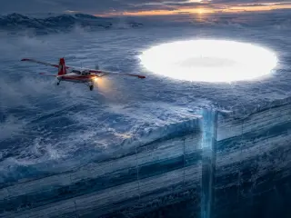
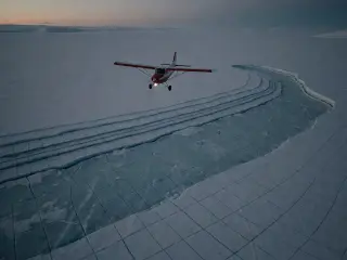
An event image has to do something a world image does not: it has to locate a single moment inside the setting and make that moment look expensive. The White Flight gives you a survey plane at dusk, a glacier cut open into year-by-year strata, a shaft dropped through a missing year, and a perfect white hole ahead of the wing with the faint silhouette of a town inside it. It is the world’s thesis in one frame — the map did not destroy the place, it removed every route to it, and someone is flying toward the gap anyway.
A Repeatable Workflow
Choose the scale
Orbit for the world statement, low aerial for the event, street level for a character or a document. Do not mix two scales in one prompt.
Name one anomaly
A white tile, a missing year, a pin in open water. One anomaly per frame; a second one turns the image into noise.
Write the overlay lexicon
List the map furniture explicitly: tile grid, survey seams, contour lines, placemark pins, graticule. Models will not add them consistently unless asked.
Render both models
Keep the prompt byte-identical across GPT Image 2 and Krea 2. The comparison is only useful if the renderer is the sole variable.
Publish the pair
Both renders publish as works of the world, which gives each image a permanent page and the setting a permanent reference pair.
Prompt Anatomy for Orbital Map Shots
An orbital map prompt is a stack of five decisions, in this order. Get the order wrong and the model will spend its detail budget on clouds instead of on the thing you actually need to show.
- Viewpoint — high orbit at a steep angle, low aerial, or straight down. Steep angles read as a planet; straight down reads as a document.
- Overlay furniture — tile grid, hairline seams, contour lines, placemark pins, and how they behave on water versus land.
- The anomaly — one white absence, one broken seam, one pin in the wrong ocean. Describe its edge, because the edge is what makes it read as erasure rather than a cloud.
- Palette — deep ocean blue, ash grey, map-cream, one warm brass light. Keep the warm light singular; two warm lights and the frame turns festive.
- Forbidden elements — no text, no labels, no watermark, no logo. Map interfaces invite typography, and typography is where these renders fail.
Use Cases
- Game settings — a modern cartographic thriller with a built-in map screen, faction layer and fast-travel problem.
- Tabletop modules — a setting where the player handout is an actual map with one tile missing.
- Series bibles — a pitch deck that needs one orbital image to explain a whole season of stakes.
- Key art and covers — paperback covers, festival posters, chapter headers, newsletter headers.
- Interactive fiction — a story where the player’s only verb is deciding which version of a place to pin.
- World-building exercises — a fast way to test whether a setting has a visual language before you write 40,000 words in it.
Common Mistakes
- Asking for a map instead of a place. “A map of Europe” gives you a graphic. “Europe seen from orbit with a survey grid registered to its curvature” gives you a world.
- Too many labels. Every model will try to render interface text and every model will misspell it. Ban text in the prompt and add any labels afterwards, or not at all.
- Two anomalies. A white hole and a red seam and a floating pin is three ideas fighting for one focal point.
- Flat grids. If the grid does not follow the planet’s curve, the image reads as a screen capture rather than a layer wrapped around a world.
- Ignoring the thumbnail. A map image has to survive being 300 pixels wide. If the anomaly disappears at that size, it is not the anomaly you needed.
Frequently Asked Questions
- Is this an official Google Earth product? No. Ground Truth is an original AI-built world inspired by satellite-map interfaces. It is not affiliated with or endorsed by Google.
- Can I use the world commercially? The world and its four published works are public and remixable on Neta Studio; check the platform terms for your intended use.
- Which model should I start with? GPT Image 2 for a hero image, Krea 2 for fast exploration and social crops. Running both on the same prompt is the cheapest way to learn the difference.
- How many atoms do I need? Ground Truth uses 27. A workable minimum is five characters, four locations, three events, two factions and three rules — enough for the map to have something to lose.
- Do I need real geography? No. Real coastlines help the interface read instantly, but the setting only works once you invent a place the map refuses to render.
Start Building
Build Your Own Map-First World
Fork Ground Truth or start from a one-sentence brief, then render the same prompt through two models and keep the pair.